Hydrodynamics
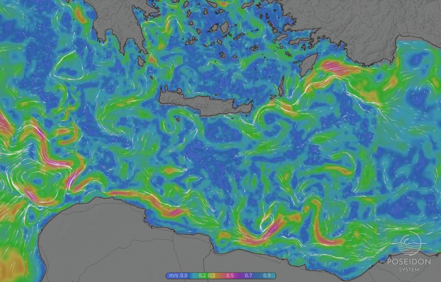
The Mediterranean ocean circulation forecasting system
Development and implemenation: HCMR
Chief Scientist: Dr. Gerasimos Korres
The Mediterranean Sea ocean forecasting system is composed of a 1/10° resolution – 24 sigma layers Mediterranean implementation of POM model (Korres et al., 2008) and a data assimilation scheme based on the Singular Evolutive Extended Kalman (SEEK) filter (Pham et al., 1998; Hoteit et al., 2005). SEEK is an error subspace extended Kalman filter that operates with low-rank error covariance matrices as a way to reduce the computational burden. The filter uses covariance localization and partial evolution of the correction directions (Korres et al., 2008). The assimilation scheme corrects the forecast state of the model on a weekly basis. The assimilated observational data set is multivariate including AVISO sea level height, AVHRR sea surface temperature, MEDARGO floats T and S profiles and XBT data.
The Mediterranean hydrodynamical model is forced with hourly momentum, heat and freshwater fluxes derived from the POSEIDON weather prediction system based on a 1/20° ETA regional non-hydrostatic atmospheric model.
The Mediterranean model provides 5-days forecasts and additionally initial and open boundary conditions to the 1/30° POM model of the Aegean Sea.
References
Hoteit, I., G. Korres and G.Triantafyllou, 2005. Comparison of Extended and Ensemble based Kalman filters with low and high resolution primitive equation ocean models. Nonlinear Processes in Geophysics, 12, 755-765.
Korres, G., K. Nittis, I. Hoteit and G. Triantafyllou, 2008. A high resolution data assimilation system for the Aegean Sea hydrodynamics. J. Mar. Syst. (in press).
Korres, G., K. Tsiaras, K. Nittis, G. Triantafyllou and I. Hoteit. The POSEIDON-II system: Forecasting at the Mediterranean scale. 5th EuroGoos Conference. Exeter, UK, May 20-22, 2008.
Pham, D., Verron, J., Roubaud, M.C., 1998. A singular evolutive extended Kalman filter for data assimilation in oceanography. J. Mar. Syst. 16 (3-4), 323-340.
The Aegean Sea hydrodynamic model
Development and implemenation: HCMR
Chief Scientist: Dr. Gerasimos Korres
The Aegean Sea hydrodynamic model is based on the Princeton Ocean model (POM) and was initially developed as part of the Poseidon-I system (Nittis et al., 2006 ; Korres et al., 2002). POM is a primitive equations free surface ocean model which operates under the hydrostatic and Boussinesq approximations. The model equations are written in sigma-coordinates and discretized using the centered second-order finite differences approximation in a staggered “Arakawa C-grid” with a numerical scheme that conserves mass and energy.
The model domain covers the geographical area 19.5°E – 30°E and 30.4°N – 41°N with a horizontal resolution of 1/30° and 24 sigma layers along the vertical with a logarithmic distribution near the surface and the bottom. The model includes parameterization of the main Greek rivers (Axios, Aliakmonas, Nestos, Evros) while the inflow/outflow at the Dardanelles is treated with open boundary techniques. The Aegean Sea model is forced with hourly surface fluxes of momentum, heat and water provided by the Poseidon - ETA high resolution (1/20°) regional atmospheric model issuing forecasts for 5 days ahead.
Nesting procedures
Boundary conditions at the western and eastern open boundaries of the Aegean Sea hydrodynamic model are provided by
1) The HCMR Mediterranean model with a resolution of 1/10° and 24 sigma layers in the vertical on an hourly basis for VERSION-I of the forecasting system.
2) the Mediterranean Ocean Forecasting System model (MFS, GNOO-INGV) covering the whole Mediterranean Sea with a resolution of 1/16° and 72 levels in the vertical on a daily basis (daily averaged fields) for VERSION-II of the forecasting system.
The nesting between the two models involves the zonal/meridional external (barotropic) and internal velocity components, the temperature/salinity profiles and the free surface elevation following the nesting procedures described in Korres and Lascaratos (2003). Additionally, volume conservation constraints between the two models are applied at both open boundaries of the Aegean Sea model.
Model initialization
The Aegean Sea model is re-initialized from the HCMR Mediterranean model (Version-I) or MFS OGCM (Version-II) analysis once every week. In order to filter out spurious oscillations that may occur during the re-initialization procedure, the VIFOP optimization tool has been implemented (Auclair et al, 2000) in the forecasting system. VIFOP is a variational initialization technique based on the minimization of a cost function involving data constraints as well as a dynamical penalty involving the tangent linear model.
Basic system attributes are summarized in the following table:
|
Version name |
VI/VII |
|---|---|
|
Type |
3D primitive equation, finite difference, free surface (based on POM code) |
|
Model region |
Aegean Sea(19.5°E -30°E; 30.4°N-41°N) |
|
Horizontal coordinate system |
Type Orthogonal curvilinear – WGS84 geographical projection |
|
Grid spacing |
1/30°×1/30° - One way nested with the Mediterranean SYS2b model |
|
Vertical coordinate system |
Sigma coordinates |
|
Vertical Grid spacing |
25 levels with logarithmic distribution near the surface and the bottom |
|
Open boundary conditions |
In cases of outflow T,S are advected upstream while in cases of inflow T,S are directly prescribed from the coarse resolution model. Internal velocities are directly prescribed from the parent model. Modified Flather condition for the external velocities. Zero gradient condition for sea level. |
Initialization procedure of new forecast cycle
|
Source |
HCMR MED/MFS MED |
|---|---|
|
Initialization method |
Variational initialization method (VIFOP) |
Surface forcings
|
Source |
POSEIDON non-hydrostatic atmospheric model |
|---|---|
|
Grid spacing |
1/20° × 1/20° |
|
Parameters |
Wind speed at 10 m, air temperature at 2 m, relative humidity, net shortwave radiation, downward longwave radiation, precipitation |
|
Frequency |
Every 1 hour |
River runoff
|
Source |
Climatological runoff data for the major Greek rivers. |
|---|---|
|
Frequency |
Monthly |
References
Auclair F., Casitas, S., Marsaleix, P., 2000. Application of an inverse method to coastal modeling. J. Atmos. Oceanic Technol., 17, 1368-1391.
Korres, G., A.Lascaratos, E. Hatziapostolou and P.Katsafados, 2002. Towards an Ocean Forecasting System for the Aegean Sea. The Global Atmosphere and Ocean System, Vol. 8, No. 2-3, 191-218.
Korres, G., and A. Lascaratos, 2003. A οne-way nested eddy resolving model of the Aegean and Levantine basins: Implementation and climatological runs. Analles Geophysicae, MFSPP – Part I Special Issue, 21, 205-220.
Nittis, K., L.Perivoliotis, G.Korres, C.Tziavos and I.Thanos, 2006. Operational monitoring and forecasting for marine environmental applications in the Aegean Sea.


